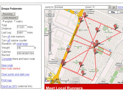
Someone has changed googlemaps to look at running routes and have a calorie burn calculator.
I'd say the only drawbacks with it are
1) it does not snap to the roads so you need to click lots of small segments, it just does a straight line between points.
2) none of the help stuff works so it took me a while to figure out how to use it.
so here you go:
1) press start recording, double click to add a point, double click at every corner etc
2) when finished add you weight
not sure what elevation is doesn't seem useful, what is cool is it allows you to save a route with its own link like this one
 *******Update*******
They guy fixed it like he said he would, it is really much better now
You can do snap to road, straight lines whatever..
Very good, thanks Mr gmap-pedometer
2 comments:
Hi, I'm the guy behind gmap-pedometer.com. Funny you should mention snapping to roads -- I agree, it really should have that. In fact, I'm about halfway through developing that, it should be ready within a couple of weeks!
Also, I've fixed the db behind the usage instructions, sorry about that.
Well I and lots of other people are very grateful to you for developing it.
Not snapping to roads has some advantages e.g. when you're running accross parks so if it could be turn off turn on-able....?
The only remaining feature in googlemaps is that when you move the points about you can see the change in total distance which helps if trying to creat an exact distance route.
Great job as they say here, lots of people I know interested, like cyclists trying to avoid hills and so on. Thanks for your comment.
Post a Comment